Town of Kearny Arizona — Project 88 Official Seal
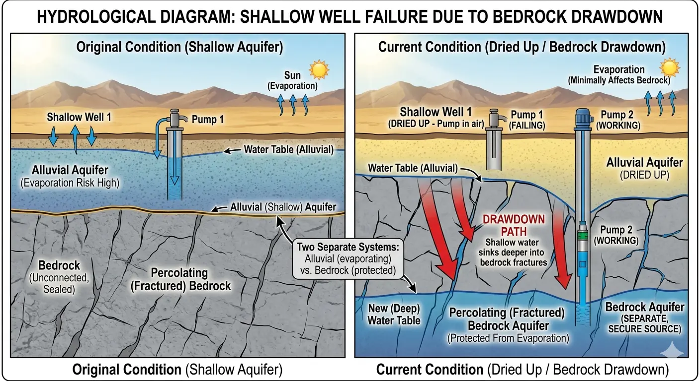
Colorado River Compact Expiring — Federal Deadline 2026

The Colorado River Crisis
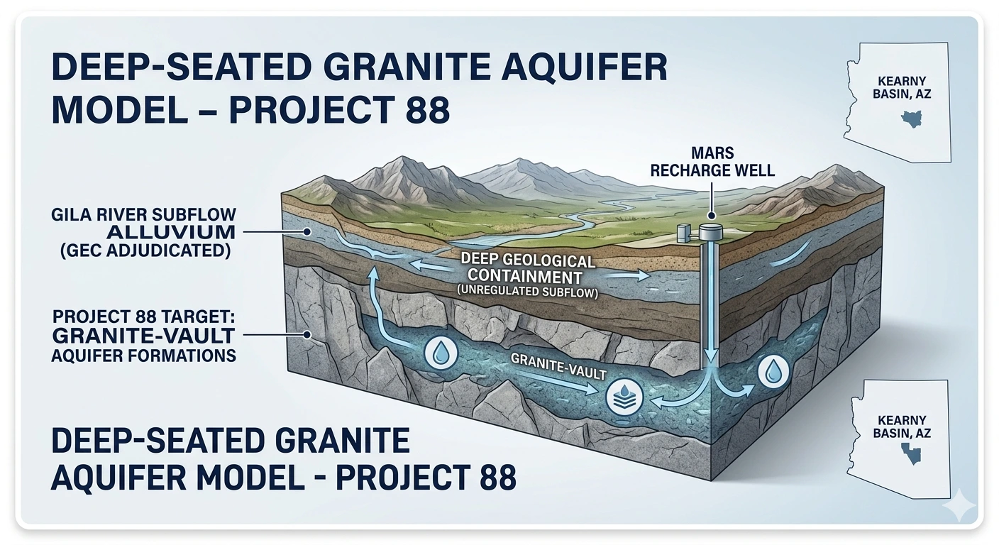
& Kearny's Shield

As the federal government forces historic cuts on Colorado River water rights, Kearny is moving to lock in its independence. Here is what is in play — and how our deep granite-vault aquifer holds the key.

7 States in Deadlock
27% Arizona's Proposed Cut
800ft The Shield Depth
1935 Globe Decree Boundary

Section 1 — The Crisis

What's Happening Across the West?

The operating guidelines for the Colorado River expire in 2026. Because the seven basin states — Arizona, California, Colorado, Nevada, New Mexico, Utah, and Wyoming — cannot agree on a deal, the Bureau of Reclamation has stepped in to prevent the total collapse of Lake Mead and Lake Powell with a strict long-term management strategy.

⚠ Bypassing "First in Time, First in Right" — Seniority Under Attack

The federal government is floating alternatives that would replace the old prior appropriation doctrine with pro-rata (equal percentage) cuts across all users — regardless of how senior their water rights are. This would upend decades of established Arizona water law and erase the seniority protection communities have held for generations.

⚠ Arizona Faces the Earliest and Deepest Cuts

Under nearly every federal scenario, Arizona faces the steepest reductions. Governor Hobbs has already offered to cut the state's Colorado River allocation by 27 percent. That cut hits every community dependent on surface river flow — unless they have already secured an independent underground source.

For Kearny, a defensive posture is not enough. Kearny needs an offensive water strategy — one that makes the Colorado River negotiations irrelevant to the Town's water future.

Section 2 — The Goal

The Best-Case Scenario for Kearny

In a world of tightening surface water restrictions, the absolute best-case scenario for our town looks like this:

★ Total Water Independence

We legally and physically isolate Kearny's water supply from the volatility of sub-river flow restrictions and surface water cutbacks. We achieve this by proving we are tapping a secure, isolated underground resource — not surface-dependent river flows. No river compact can reassign it. No federal guideline can reduce it. It belongs to Kearny under Arizona state law.

Kearny already has the foundation most Arizona municipalities would spend millions to acquire: confirmed deep granite-vault aquifer wells, camera-inspected, water present, sitting below 800 feet. The question is whether the Town files to own that water — before someone else does.

Section 3 — Why Shallow Wells Are Failing

Bedrock Drawdown: What's Already Happening to Kearny's Surface Water

Before understanding the solution, it is important to understand the problem at ground level. As drought intensifies and surface aquifers drop, shallow alluvial wells across the region are experiencing a dangerous phenomenon called bedrock drawdown — where the surface water table collapses and water migrates deeper into fractured bedrock formations, leaving shallow pumps running in air.

Diagram 1 Hydrological Diagram — Shallow Well Failure Due to Bedrock Drawdown
Hydrological diagram comparing original shallow aquifer condition versus current dried-up bedrock drawdown condition. Shows shallow well failure, alluvial aquifer drying up, drawdown path into fractured bedrock, and the emergence of a separate secure bedrock aquifer source below.
Left: Original condition — shallow alluvial aquifer with high evaporation risk, wells functioning at surface water table. Right: Current condition — alluvial aquifer dried up, shallow well failing, water migrating via drawdown path into Percolating (Fractured) Bedrock Aquifer — now a separate, secure source protected from evaporation. This is the hydrological process that makes Kearny's deep Vault wells a permanent asset.

The diagram above shows precisely what is happening in Kearny's basin right now. Shallow surface-connected water is evaporating and declining. But deeper, beneath the fractured bedrock layer, a separate and protected water source is forming — fed by percolating water that has moved below the evaporation zone entirely. This is not a liability. It is an opportunity — if the Town files to own it.

Section 4 — The Legal & Geological Shield

The 800-Foot Mark & the 1935 Globe Decree:
Why Depth Is Everything

To secure long-term water rights and shield Kearny from federal or state cutbacks, we have to look down — specifically, beneath the 800-foot mark in the Kearny Basin. Understanding why requires understanding the most powerful competing legal mandate Kearny faces: the 1935 Globe Equity Decree.

⚖ The 1935 Globe Equity Decree — The Primary Competing Mandate

The Globe Equity Decree of 1935 is a federal court adjudication governing water rights along the Gila River system in Arizona — including alluvial groundwater directly connected to Gila River subflow. Any well drawing from shallow water hydrologically connected to subflow is operating under the Globe Decree's shadow — subject to curtailment, tribal senior claims, and federal reallocation. This is the primary competing mandate Kearny must defeat to achieve water independence. The solution: go deeper than the Decree can reach.

⬛ Surface Level — Town of Kearny / Kearny Basin, AZ
Drilling down — entering Gila River subflow zone
0 – 800 ft  |  Gila River Subflow / Alluvial Zone — GLOBE DECREE TERRITORY
Water at this depth is alluvial groundwater hydrologically connected to Gila River subflow. It is adjudicated under the 1935 Globe Equity Decree and is legally considered part of the Gila River system. Tribal nations hold senior priority rights under federal law. State and federal regulators can restrict pumping from this zone to protect downstream river commitments. And the federal push to bypass seniority on the Colorado River sets a precedent that could embolden similar reallocation pressure statewide.
⚖ Globe Equity Decree (1935): Wells in this zone are subject to Gila River adjudication. Tribal senior rights holders can seek curtailment. Federal pro-rata Colorado River cut frameworks can reduce this supply. This is the zone Kearny must move beyond.
████   THE SHIELD — Impermeable Granite / Confining Rock Layer — ~800 ft   ████
Below this point: believed geologically isolated from Gila River subflow — where Globe Decree jurisdiction is expected to end (pending hydrological confirmation)
Crossing the threshold — entering deep percolated granite-vault zone
800+ ft  |  Deep Granite-Vault Aquifer — PROJECT 88 TARGET ZONE
Water at this depth has filtered through thousands of feet of granite rock over millennia. It is believed to be geologically isolated from Gila River alluvial flows — not subflow — a classification the hydrological study now underway is designed to confirm. It is deep percolated groundwater in confined granite-vault formations. If that classification is confirmed, establishing prior appropriation here could place Kearny's supply outside the Globe Decree's reach — a water source that would belong to the Town under Arizona state law.
✓ Vault Well 1 — Confirmed ✓ Vault Well 2 — Confirmed ↑ Well 3 — Coming Online ★ MARS Recharge Zone
Diagram 2 Deep-Seated Granite Aquifer Model — Project 88  |  Kearny Basin, AZ
Deep-Seated Granite Aquifer Model showing Gila River Subflow Alluvium (GEC Adjudicated) in upper layers, Deep Geological Containment zone (Unregulated Subflow) as transition, and Project 88 target Granite-Vault Aquifer Formations at depth with MARS Recharge Well drilling down to the protected zone.
Upper layers: Gila River Subflow Alluvium — adjudicated under the 1935 Globe Equity Decree (GEC). Subject to tribal senior rights and federal curtailment. Middle zone: Deep Geological Containment — Unregulated Subflow transition layer. Deep zone: Project 88 Target — Granite-Vault Aquifer Formations. Below Globe Decree jurisdiction. MARS Recharge Well penetrates all layers to bank water directly into the protected deep zone.

The Town of Kearny is a political subdivision of the State of Arizona — it has full legal standing to file this appropriation right now. A prior appropriation filing establishes Kearny's seniority date. Every competing claim filed after that date is junior. Permanently. And if the Vault wells are confirmed to tap water below the Globe Decree's reach, the filing may fall outside Gila River adjudication entirely — the precise question the hydrological study is designed to settle.

⚠ Surface Risk (0–800 ft)
  • Gila River alluvial subflow — Globe Decree territory
  • Tribal nations hold senior federal priority rights
  • Exposed to the federal precedent bypassing seniority rights
  • Statewide cutback pressure threatens surface-dependent supply
  • Alluvial aquifer drying up via bedrock drawdown
  • Mine dewatering competes in same formation
✓ Deep Granite-Vault (800+ ft)
  • Likely below Globe Decree adjudication — pending confirmation
  • Not Gila River subflow — independent source
  • Prior appropriation locks Kearny's seniority date
  • If confirmed independent, no federal river compact could reassign it
  • Confined granite aquifer immune to surface drought
  • First filing = senior right over all later claims

Section 5 — The Long-Term Play

Transitioning to MARS: Managed Aquifer Recharge & Storage

Securing the deep water rights allows Kearny to transition from a reactionary setup to a permanent, sustainable MARS (Managed Aquifer Recharge and Storage) framework. Instead of simply mining the aquifer, MARS allows the Town to actively manage, store, and recycle water assets underground — building a self-replenishing hydrological bank owned entirely by Kearny.

1
Phase 1 — Security

Deep Well Capture

Draw exclusively from the protected granite-vault formations below 800 feet — below the Globe Decree's reach. Guarantees baseline municipal supply independent of any surface water restrictions or federal river management decisions.

2
Phase 2 — Collection

Capture Effluent & Surpluses

Direct treated municipal effluent and seasonal stormwater runoff into dedicated, permitted containment areas rather than letting it evaporate or escape downstream. This water becomes the feedstock for the MARS recharge cycle.

3
Phase 3 — Recharge

Controlled Percolation

Using engineered spreading basins or shallow injection fields, allow collected water to filter down through the soil profile — purifying it as it recharges the upper water table and the deep containment zone. Water banked under Kearny's name.

4
Phase 4 — Sustainability

The Hydrological Bank

The recharged water forms Kearny's underground water bank. By putting water back in, the Town offsets deep pumping, stabilizes the local water table, and completely insulates itself from regional river restrictions — now and for future generations.

Section 6 — The Action Plan

The Path Forward — Already Underway

Mayor Curtis Stacy is taking the right path forward. Rather than rushing, he has engaged Mackenzie and Associates, an independent hydrology firm, to professionally investigate whether Kearny's deepest wells lie beyond the Globe Decree's reach — the exact question that has to be answered before the Town can act. That measured, evidence-first approach aligns squarely with the goal Project 88 has championed from day one: verify the deep-water opportunity, then secure it. The Town and Project 88 want the same outcome — a confirmed, independent water supply Kearny can own for generations. The urgency is real: mine dewatering operations and tribal water-right adjudications are active in the region, so the verification work happening now is exactly the right first move.

1

File Prior Appropriation Under A.R.S. § 45-151

Mayor Stacy files an application to appropriate the deep groundwater of the Vault wells for municipal beneficial use with ADWR. This establishes Kearny's priority date — the legal timestamp that makes the Town senior to all future filers in the deep granite-vault zone.

2

Hydrological Study — Underway with Mackenzie and Associates

This step is already in motion. The Town has engaged Mackenzie and Associates to determine whether the Vault wells tap water below the 800-foot confining layer — geologically isolated from Gila River alluvial subflow. If confirmed, this is the legal firewall that could place Kearny's appropriation outside Globe Decree jurisdiction and beyond the reach of tribal senior rights. The study's findings will tell the Town where it stands.

3

Designate All Vault Wells Below 800 ft as Exclusive Municipal Infrastructure

Formally classify the entire Vault well system as exclusive municipal water infrastructure under Arizona groundwater law — shielding it from agricultural conversion, third-party industrial use, or mine dewatering claims in the same formation.

4

Initiate MARS Phase 1 — Establish Documented Beneficial Use

Launch deep well capture under the MARS framework to create a documented, legally defensible record of ongoing municipal beneficial use — the requirement that cements an Arizona prior appropriation and prevents abandonment challenges under A.R.S. § 45-189.

5

Bring Well 3 Online & Register ADWR Underground Storage Facility

Extend the appropriation filing to cover Well 3 as it comes online. Apply for ADWR Underground Water Storage Facility designation under A.R.S. Title 45 Chapter 3.1 — converting MARS recharge activity into legally accrued water storage credits owned exclusively by the Town of Kearny.

★ The Bottom Line

The 1935 Globe Decree, the Colorado River compact expiration, mine dewatering activity, and tribal water adjudications are all converging on the same window: 2026. Communities that establish seniority now in the deep granite-vault zone — if the hydrology confirms it sits beyond the Globe Decree's reach — will enter the post-2026 water era as independent, water-secure towns. Kearny has the wells, the legal standing, and a Mayor who has put the right verification work in motion. The window is measured in months.

Support Project 88.
Protect Our Aquifer.

Securing Kearny's deep wells and building a permanent recharge solution requires proactive local governance and community backing. Let's build the infrastructure that ensures Kearny never runs dry.

← Back to SaveKearnyAZ.org View Project 88 →