💧 WATER WATCH — Level 1WE (Voluntary Conservation)  |  Temporary Priority Water Now Flowing  |  Relief Ends the Moment a Senior User Calls for Water  |  Conserve — Every Drop Still Counts
The Situation Wells What To Do Wastewater Update Project 88 / MARS ⚡ Water Rights Now ★ Your Voice — Community Contact
Kearny, Arizona — Live Water Status

Our Town. Our Water. Our Fight.

Kearny sits along the Gila River in Pinal County, Arizona — a century-old copper and ranching town of about 2,000 people. In 2026 its surface-water allotment was cut to 77 acre-feet, triggering a declared water emergency. This page tracks the facts, the response, and the path forward — updated as the situation changes.

77
Acre-Feet Allotted
for All of 2026
<0.05%
Coolidge Dam
Capacity (Jun 2026)
32.7%
Reduction Achieved
by Residents
1WE
Current Restriction
Level (Voluntary)

"What makes the desert beautiful is that somewhere it hides a well."

— Antoine de Saint-Exupéry, The Little Prince

🔔 Colorado River Compact expires 2026
|
⚖️ 1935 Globe Decree — competing claims active now
|
📅 August 2026 — federal operative deadline
|
💧 2 Vault Wells confirmed — prior appropriation not yet filed
Town of Kearny Arizona — Project 88 Official Seal
The Bigger Picture — The 2026 Window

Why Water Decisions for Kearny
Have to Be Made Right Now

The drought is local. The legal threats are statewide. The federal deadline is national. And Kearny's answer — two confirmed deep granite-vault wells — is sitting right beneath the town's feet, waiting on a single filing that could change everything.

Kearny's immediate water emergency is real and it is being fought — hard. But there is a second crisis forming on a different timeline, and it is just as dangerous. The rules governing every drop of water in the American Southwest are being rewritten right now, and communities that don't act before the rules are finalized will spend the next generation living under whatever they're handed.

Seven states have missed multiple federal deadlines to agree on how to share the Colorado River after 2026. The federal government is now proposing to replace Arizona's hard-won prior appropriation seniority with pro-rata cuts — equal percentage reductions for everyone, regardless of how old or senior your water rights are. Arizona's Governor has already offered to give up 27% of the state's river allocation just to stay at the table.

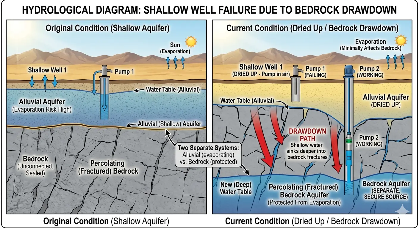
At the same time, the 1935 Globe Equity Decree — the same ruling that slashed Kearny's allotment to 77 acre-feet — extends its reach over any groundwater connected to Gila River subflow. But Kearny's confirmed Vault wells punch below 800 feet into a granite formation that may sit outside the Decree's jurisdiction. Under Arizona's prior appropriation doctrine, the first municipality to file on that deep water would hold senior rights to it — ahead of every claim that comes after. Formal hydrogeological confirmation is the step that makes that protection legally durable.

Mine dewatering operations and tribal water adjudications in this region are active today. Mayor Stacy and the Town Council have full legal standing to file under A.R.S. § 45-151. The wells are in the ground, and the hydrology is being professionally verified now. Every month without a filing is a month any competitor can establish seniority first.

27%AZ River Allocation
Already Offered
1935Globe Decree
Competing Mandate
800ftTarget Depth — Believed
Below Globe Jurisdiction
2 WellsConfirmed Water
No Filing Yet
Read the Full Water Independence Plan → View Project 88 / MARS ↗
⚖️  The 1935 Globe Equity Decree

A federal court ruling governing all Gila River-connected groundwater. Kearny's allotment was cut from 610 to 77 acre-feet under this decree. Any well above 800 feet is subject to it. Kearny's Vault wells go deeper — but only a filed prior appropriation makes that protection legally permanent.

🌊  Colorado River Compact Expiration — 2026

Seven states remain deadlocked. The feds are proposing pro-rata cuts for all users — bypassing prior appropriation seniority entirely. Arizona has already offered a 27% reduction. That cut lands hardest on communities with no independent, legally secured water source.

⛏️  Mine Dewatering & Competing Claims

Active mining operations in the Kearny region are pursuing dewatering permits drawing from the same deep formations as the Vault wells. Under Arizona's prior appropriation doctrine: the entity that files first holds senior rights — permanently. Every day of inaction is a day a competitor can file ahead of the Town.

💧  Kearny's Answer: The Granite-Vault Aquifer

Below 800 feet, Kearny sits above a confirmed deep granite-vault aquifer — camera-inspected, water present, below Globe Decree jurisdiction. With a prior appropriation filing and MARS recharge, this becomes a permanent water bank no federal compact can ever reassign.

The Three Core Threats

The Three Legal & Environmental Threats
Facing Kearny's Water Supply.


Three forces are converging on Kearny's water supply. The first is a severe, prolonged drought that has drained Coolidge Dam to less than 0.05% of its capacity. The second is a 91-year-old federal court decree that places Kearny last in line for every remaining drop. The third is a set of competing legal claims that could challenge any unguarded groundwater right.

🔥

Threat #1 — The Drought

Arizona is in the grip of a mega-drought unprecedented in modern recordkeeping. Coolidge Dam — the sole source of Kearny's water allocation — has drained to roughly 377 acre-feet out of its ~910,000 acre-foot capacity (USGS, June 7 2026) — its surface down more than 13 feet since January 1 and falling every month since March. Snowpack ran at just ~25% of normal. No monsoon relief in sight. The taps are running on borrowed time.

~377 AF — <0.05% (Jun '26)
⚖️

Threat #2 — The Globe Equity Decree of 1935

A federal court decree that divides Gila River water among competing users. Kearny's rights are "junior" — established later than neighboring communities and tribal nations. Under the prior appropriation doctrine, senior rights drink first. When the dam runs dry, Kearny is the first to be cut off. In 2026, that cut was devastating: from about 610 acre-feet down to 77.

610 → 77 Acre-Feet
📜

Threat #3 — The Competing Legal Claims

Water rights attorneys representing senior appropriators and tribal nations could challenge any loose or unexercised groundwater claim along the Gila River corridor. Without clear legal standing on Kearny's deep wells, the town risks losing access to the very infrastructure sitting beneath its feet.

Legal Battle Looming

The Math — Zero Day

Before conservation efforts began, Kearny was on track to hit "zero water day" by July 15, 2026. You turn on your faucet and nothing comes out — for any purpose. Drinking, bathing, cooking, sanitation — all gone. That's not a hypothetical. That's the trajectory Mayor Stacy communicated in the April 8 emergency letter.

Originally: July 15, 2026
The Human Cost

The Pool Is Empty.
The Laughter Has Stopped.


The Kearny town pool wasn't just a pool. It was where kids learned to swim. Where families gathered on summer afternoons. Where the community came together. Now it sits empty — a concrete monument to what this crisis has already taken.

Kids swimming in the Kearny town pool — before the crisis
✦ Before — Summer Days at the Town Pool
Empty Kearny town pool — no water, no kids, no laughter
✦ After — Not a Drop. Not a Sound.
"When you drain the pool, you don't just lose water.
You lose the heart of a community."
— A Kearny Resident
Abandoned buildings — what could happen if water runs out

This Is What Happens When a Town Runs Out of Water.

Arizona is full of ghost towns. Places where the mine closed, the well went dry, or the people just gave up. Kearny has watched it happen to its neighbors. The abandoned buildings. The empty streets. The silence where children used to play.

This will not be Kearny's fate. Not if Mayor Curtis Stacy and the Town Council have anything to say about it. Not if the residents who have already cut their water usage by nearly a third have anything to say about it. And not if the MARS technology beneath their feet lives up to its promise.

Local Leadership & the Response

The Leadership Steering
Kearny's Water Response.


Mayor Curtis Stacy — Town of Kearny, Arizona

Curtis Stacy

Mayor — Town of Kearny, AZ

Leadership Under Fire.
Action Over Panic.

When the Gila Water Commissioner delivered the devastating news — 77 acre-feet for all of 2026 — Mayor Curtis Stacy didn't flinch. He declared a Level 5WE Water Emergency under A.R.S. § 26-311, implemented immediate mandatory conservation, and began mobilizing every resource available to secure Kearny's water future.

Under his leadership, the Town has activated emergency well rehabilitation, opened negotiations with ASARCO and Resolution Copper, engaged the Governor's Water Policy Office, secured a USDA-funded well rehabilitation contract, and pursued EPA grant funding through Congressman Crane's office.

"There are 2,000 people here that I am responsible for."
— Mayor Curtis Stacy

The results speak for themselves. Residents cut usage by nearly a third, and by early June 2026 the Town had secured temporary “priority water” from the Decree area — enough to ease restrictions all the way down to Level 1WE (voluntary conservation). But the Town has been clear this reprieve is almost certainly temporary: it ends the moment a senior-rights holder calls for that water. Conservation and borrowed water buy time — they don't win the fight. That's where MARS and Project 88 come in.

Stakeholders Across the Gila River System

Securing Kearny's future means engaging everyone with a stake in the Gila. These are the parties involved in — or relevant to — that effort:

Town CouncilASARCOResolution CopperGovernor's Water Policy OfficeCongressman Crane's OfficeSenator RogersCounty Attorney MillerGila River Indian CommunityGila River Water CommissionerUSDAADWRProject 88

Listed parties are stakeholders in the Gila River system. Inclusion reflects engagement or relevance to the water question and does not imply endorsement of Project 88 or any specific commitment to the Town of Kearny.

The Scoreboard

Kearny Is Fighting Back


Usage Reduction (7-Day Avg)

32.7%
Goal: 30%+ ✅ At goal (7-day avg, Town update 6/4/26)

Water Reclaim Rate

~48%
Goal: 60–70% recapture | Continue capturing grey water

Restriction Level Eased

5WE → 1WE
Eased June 2026 after securing temporary priority water. Voluntary conservation continues.
The Science Behind Project 88

Understanding the Two Aquifers
Beneath Kearny

Why shallow wells are failing — and why going deeper changes everything.


Most of Kearny's existing water infrastructure was built to tap alluvial aquifers — shallow, sandy layers of river sediment near the surface. These aquifers recharge from rainfall and river flow. The problem? They also lose water to evaporation, and during a mega-drought, they dry up fast. When alluvial wells fail, pumps spin in open air and the taps go silent.

But beneath that alluvial layer sits something entirely different: fractured bedrock. Granite formations riddled with natural fractures that collect and store water deep underground — protected from evaporation, protected from surface drought, and potentially outside the reach of the Globe Equity Decree. This is the water Project 88 is designed to find.

The diagram below shows exactly what's happening beneath Kearny — and why drilling deeper into the granite aquifer isn't just an option. It may be the only path to permanent water security.

Hydrological diagram showing shallow alluvial well failure due to bedrock drawdown
Shallow Well Failure vs. Deep Bedrock Aquifer — The Project 88 Approach
⚠ The Problem

Alluvial Wells Are Drying Up

Shallow wells draw from river sediment that evaporates rapidly in drought. When the water table drops, pumps hit air. That's exactly what's happening in Kearny right now — and across the American Southwest.

✦ The Solution

Bedrock Aquifer — A Separate Source

Fractured granite at 1,000+ feet stores water in natural vaults, shielded from evaporation and surface conditions. Deeper wells accessing this formation could tap a completely independent water supply — drought-resistant and, if confirmed, legally distinct.

"Whiskey is for drinking; water is for fighting over."

— Mark Twain

And Kearny is ready to fight.

🤠

The Wider Pattern — South Texas Turns to Groundwater

In 2025–2026, Beeville, Texas faced a severe water crisis as Lake Corpus Christi — its primary surface source — fell toward record lows. City leaders responded by rehabilitating capped wells and drilling new ones, backed by a $35 million bond, to tap groundwater beneath the failing surface supply. That groundwater is brackish and requires reverse osmosis treatment, and officials describe the new wells as a stopgap while longer-term solutions come online. The broader pattern is the point: across the drought-stricken Southwest, when surface water fails, communities are turning to the water beneath their feet. Kearny may already own deep wells worth verifying for exactly that reason — which is what the current hydrological study is for.

"Anyone who can solve the problems of water will be worthy of two Nobel prizes—one for peace and one for science."

— John F. Kennedy

The Path to Water Independence

Project 88 — Finding Water
Where No One Thought to Look


Kearny's most promising long-term option is MARS: Managed Aquifer Recharge and Storage — a proven hydrological approach already deployed in Phoenix, Tucson, and across the American Southwest.

Project 88 asks one simple question: Does Kearny already own the solution to its own water crisis?

Our research of ADWR public records has identified two deep-bore wells — Sites 23CCC (1,250 ft) and 23CAA (1,150 ft) — that show as "Data Gaps" in current records. At that depth, these wells punch through the alluvial layer the Globe Equity Decree governs and into fractured granite — a formation that produces cleaner, drought-resistant water from a completely separate legal classification called percolating groundwater.

The Decree's handcuffs have a geological floor. Project 88 is here to find it — and if the geology confirms what the data suggests, to help Kearny develop a water supply that no drought and no 1935 decree can touch.
🔍

The Vault Wells

Two dormant wells at 1,150–1,250 ft depth with 18-inch casings — capable of 2,000+ GPM if rehabilitated. Infrastructure worth $500K–$1M to replicate, already sitting inside city limits, waiting to be verified.

⚖️

Below the Decree

The Globe Equity Decree governs alluvial subflow — saturated Holocene sediment near the river surface. At 1,250 feet in fractured granite, these wells may access legally separate percolating groundwater outside the Decree's reach.

💧

The Effluent Strategy

Stop sending treated effluent downstream for free. Inject it back into the Vault wells and earn ADWR Long-Term Storage Credits — a water bank Kearny owns outright, recoverable on demand under ARS Title 45.

🤝

No Upfront Cost

Project 88 operates on a verify-first model. Phase 1 is a site inspection — nearly free. No capital commitment until the data confirms the opportunity is real. The Town risks nothing.

Progress — June 2026

Independent Review Underway

In June 2026, the Town of Kearny engaged Mackenzie and Associates, an independent hydrology firm, to conduct a hydrological study of the basin's deep-well and managed-recharge options — evaluating the Project 88 concept alongside other approaches under consideration.

This is the verification step that determines whether the deep Vault wells can deliver the independent, decree-exempt supply this plan envisions. The idea is no longer just on paper — it's being professionally studied.

Project 88 is an independent citizen initiative and is not an official program of the Town of Kearny. The hydrological study is being conducted to evaluate multiple options; inclusion of the Project 88 concept does not imply a commitment to it.

Infrastructure Report

21 Wells Beneath Kearny


The wells beneath Kearny tell the story of the town itself. The first holes were hand-dug by homesteaders chasing shallow water along the Gila River bottom. When the copper boom arrived, the mining companies needed industrial water — and they drilled deeper, harder, and wider. Two of those wells punched through 1,100+ feet of fractured granite with 18-inch casing built for high-volume production. They were overbuilt on purpose — drought-resistant infrastructure designed to outlast any dry spell. Today, those two "Vault" wells may hold the key to Kearny's survival. Here is every well within city limits, from the shallowest domestic holes to the deepest assets in the basin.

A note on well numbering: The deep "Vault" wells discussed here (ADWR Sites 23CCC and 23CAA) are separate from the Town's current USDA rehabilitation project (its Wells 3 and 4), which are modest supplemental producers. The Vault wells' high-yield potential is a prospect still pending the hydrological study — not a confirmed figure.

Well #1 · Site 23CCC
"The Vault" — Primary
Project 88 Priority
The crown jewel. 1,250 feet deep with 18-inch casing — built for high-volume public supply. Punches through alluvial sediment into fractured granite, potentially below Globe Equity Decree jurisdiction. Currently capped and showing as a Data Gap in ADWR records.
Depth
1,250 ft
Casing
18"
Elevation
2,065 ft
Potential
2,000+ GPM
Well #2 · Site 23CAA
"The Vault" — Secondary
Project 88 Priority
Second deep-bore asset at 1,150 feet. Highest elevation in the entire inventory at 2,240 ft. Also showing as a Data Gap — no casing data on file. Infrastructure worth $500K–$1M to replicate, sitting dormant and unverified inside city limits.
Depth
1,150 ft
Casing
Unknown
Elevation
2,240 ft
Potential
2,000+ GPM
Well #3 · Site 23CDB
Deep Monitor Well
Active Monitor
Active public supply well at 1,150 feet with 13-inch casing. Drilled in 1966 during the mining era. Water level measured at 389 ft below surface — deep but confirmed present.
Depth
1,150 ft
Casing
13"
Water Level
389 ft
Drilled
1966
Well #4 · Site 35CAA
South Basin Supply
Active Monitor
600-foot public supply well with 8-inch casing, drilled 1967. Water sits at just 22.7 feet below the surface — one of the shallowest water levels in the inventory.
Depth
600 ft
Casing
8"
Water Level
22.7 ft
Drilled
1967
Well #5 · Site 35ACC
South Basin Supply #2
Active Monitor
500-foot public supply well with 10-inch casing, drilled 1978. Shallow water at 22.2 ft — nearly identical to neighboring 35CAA. Confirms robust shallow aquifer near the Gila River.
Depth
500 ft
Casing
10"
Water Level
22.2 ft
Drilled
1978
Well #6 · Site 22CDB
West Ridge Well
Secondary Review
400-foot well with 8-inch casing — the newest in the inventory, drilled in 2019. Water at 160 ft below surface. Worth evaluating for supplemental capacity.
Depth
400 ft
Casing
8"
Water Level
160 ft
Drilled
2019
Well #7 · Site 27CCA2
Central Basin Monitor
Secondary Review
291-foot well, no casing data. Water measured at 39 ft — last reading was 1958. Needs updated water level measurement.
Depth
291 ft
Casing
Water Level
39 ft
Last Read
1958
Well #8 · Site 27CCC3
West Corridor — Unused
Low Yield
130-foot well with 16-inch casing, drilled 1994. Despite the large casing, classified as unused/low yield. May have value as a MARS recharge injection point.
Depth
130 ft
Casing
16"
Water Level
12 ft
Drilled
1994
Well #9 · Site 27DCC
River Bottom Monitor
Active Monitor
110-foot well with 8-inch casing, drilled 1966. Water at 12.4 ft. 37 water level readings on file — key for tracking alluvial trends.
Depth
110 ft
Casing
8"
Water Level
12.4 ft
Readings
37
Well #10 · Site 34ABB
South Central Monitor
Active Monitor
107-foot well with 6-inch casing, drilled 1953. Water at 10 ft. Consistent readings provide valuable long-term aquifer data.
Depth
107 ft
Casing
6"
Water Level
10 ft
Drilled
1953
Well #11 · Site 23DDA
North Corridor Shallow
Shallow Asset
100-foot well with 8-inch casing, drilled 1966. Water at just 8 ft below surface — among the shallowest in the inventory.
Depth
100 ft
Casing
8"
Water Level
8 ft
Drilled
1966
Well #12 · Site 23DDB
North Corridor Shallow #2
Shallow Asset
100-foot well with 6-inch casing, drilled 1966. Water at 5.5 ft — the shallowest confirmed water level in Kearny.
Depth
100 ft
Casing
6"
Water Level
5.5 ft
Drilled
1966
Well #13 · Site 27BDD
Central Domestic Well
Shallow Asset
82-foot domestic well with 6-inch casing, drilled 1951. One of the oldest surviving wells in Kearny. Water at 17 ft.
Depth
82 ft
Casing
6"
Water Level
17 ft
Drilled
1951
Well #14 · Site 34BAA
South Irrigation Well
Shallow Asset
75-foot irrigation well with 16-inch casing, drilled 1952. Large casing suggests it was built for volume. Potential MARS recharge candidate.
Depth
75 ft
Casing
16"
Water Level
9 ft
Drilled
1952
Well #15 · Site 34BBA
South Monitor — Most Data
Shallow Asset
62-foot well with 8-inch casing, drilled 1949. The most documented well in the basin with 47 water level readings on file.
Depth
62 ft
Casing
8"
Water Level
8 ft
Readings
47
Well #16 · Site 27CCA1
Recreation Well
Shallow Asset
57-foot recreation well with 8-inch casing, drilled 1968. Likely served the town pool or park system. Water at 35 ft.
Depth
57 ft
Casing
8"
Water Level
35 ft
Drilled
1968
Well #17 · Site 33ABB
West Domestic Well
Shallow Asset
54-foot domestic well with 8-inch casing. Water at 28.9 ft. Last measurement taken in 1994 — over 30 years without an update.
Depth
54 ft
Casing
8"
Water Level
28.9 ft
Last Read
1994
Well #18 · Site 35DBB1
Southeast Irrigation
Data Gap
Depth unknown. Classified for irrigation use. Drilled 1952. Water at 15 ft. Needs field verification.
Depth
Unknown
Casing
Water Level
15 ft
Drilled
1952
Well #19 · Site 28DBD
West Basin Unknown
Data Gap
Depth unknown with 4-inch casing. Water at 20.6 ft. Last reading in 2006. Needs field visit.
Depth
Unknown
Casing
4"
Water Level
20.6 ft
Last Read
2006
Well #20 · Site 35AAA
East Basin — 30" Casing
Data Gap
Depth unknown but the 30-inch casing is the largest in the entire inventory — a massive pipe suggesting serious industrial intent. This well demands investigation.
Depth
Unknown
Casing
30"
Water Level
23.1 ft
Last Read
2006
Well #21 · Site 35DBB2
Southeast Basin
Data Gap
Depth unknown, no casing data. Drilled 1967. Water at just 7 ft — extremely shallow. Neighbor to 35DBB1.
Depth
Unknown
Casing
Water Level
7 ft
Drilled
1967
Project 88 Priority
Active Monitor
Secondary Review
Shallow Asset
Low Yield
Data Gap
Current Restrictions — Level 1WE (Voluntary)

What You Can Do Right Now


As of the Town's June 4, 2026 update, Kearny is at Water Conservation Level 1WE — voluntary self-regulation. Because temporary priority water is flowing, the harsh 5WE prohibitions have been lifted and residents can live normally again. The Town has cautioned this easing is almost certainly temporary and could revert the moment a senior-rights holder calls for water — so smart conservation habits still matter.

Lawn & Landscape Watering — Permitted

Allowed again under Level 1WE. The Town asks you to keep irrigation to a reasonable minimum and conserve voluntarily.

Vehicle Washing — Permitted

Allowed under Level 1WE. Good conservation habits are still encouraged.

Pool Filling — Permitted (Any Size)

Pools, spas, and kiddie pools may be filled under Level 1WE.

Everyday Life — Back to Normal

Flush, shower, do laundry, keep the trees alive. The strict 5WE limits on essential use have been lifted.

⚠️

Driveway & Sidewalk Washing — Please Refrain

Technically permitted, but the Town asks residents to avoid washing paved surfaces and keep practicing good conservation.

⚠️

Dust Control / Corrals / Dirt Roads — Please Refrain

Asked to avoid using municipal water for this. Exception: lake water may be used if you pump and haul it yourself.

Grey Water Reuse — Encouraged

Capturing grey water from showers and sinks for outdoor plants is still appreciated and encouraged.

Fix All Leaks

Check toilets — the most common hidden leak source. Town staff can assist. Call Town Hall if you need help.

Per the Town of Kearny's June 4, 2026 update — Water Conservation Level 1WE (voluntary self-regulation) under A.R.S. § 26-311. The Town has cautioned this easing is almost certainly temporary and tied to the continued flow of priority water.

Common Questions

Frequently Asked


How is Kearny's water allotment calculated?+
The amount of water in Coolidge Dam (San Carlos Reservoir) determines Kearny's annual apportionment. With the dam at less than 0.05% of capacity (about 377 of 910,000 acre-feet) as of June 2026, the allotment was slashed to just 77 acre-feet for the entire year.
Why are other towns like Hayden not affected the same way?+
Kearny's water rights are "junior" — established later than neighboring towns. Under the prior appropriation doctrine, senior rights get water first. Kearny feels the shortage before anyone else.
What water restriction level is Kearny at right now?+
As of the Town's June 4, 2026 update, Kearny is at Level 1WE — voluntary conservation. Temporary “priority water” from the Globe Equity Decree area is currently flowing and does not count against the Town's apportionment, which let the Town ease the earlier Level 5WE restrictions. The Town has cautioned this reprieve is almost certainly temporary and can end the moment a senior-rights holder calls for that water — which is exactly why securing an independent, decree-exempt supply still matters.
What happens if we run out of water?+
You turn on your faucet and nothing comes out — for any purpose. Drinking, bathing, cooking, sanitation — all gone. That's the reality Mayor Stacy described in the April 8 emergency letter, when the town was on track to reach zero around July 15. Resident conservation and temporary priority water have since pushed that danger back and eased restrictions to Level 1WE — but the underlying shortage hasn't gone away.
What is MARS and why does it matter?+
MARS stands for Managed Aquifer Recharge and Storage. It's a proven technology used across Arizona that allows treated water to be injected back into underground aquifers for long-term storage and recovery. For Kearny, MARS could turn treated effluent — currently sent downstream for free — into a permanent water bank the Town owns and controls.
Can tribal nations take Kearny's deep well water?+
Tribal water rights under the Globe Equity Decree apply to alluvial subflow — water in shallow river sediment. At 1,150–1,250 feet in granite, Project 88 believes these wells access percolating groundwater — a separate legal category the Decree does not govern. This requires formal hydrogeological confirmation.
What is the reclaim percentage and why does it matter?+
It measures how much water is returned to the wastewater treatment plant vs. how much is pumped out. The goal is 60–70%. Currently around 48–50%. Higher reclaim means less net draw on the allotment — and more water to potentially inject back underground via MARS.
Explore More

More Resources


How You Can Help Right Now

Add Your Voice for Water Independence

Mayor Stacy and the Council are already fighting hard. Residents can strengthen that effort by showing the Town — and outside funders — that the community wants the deep-well prior appropriation filing prioritized. Call Town Hall, or read the message below at the next Council meeting.

✉ A Message You Can Use

“As a member of the Kearny community, I support the Town moving quickly to secure our water future. I urge the Mayor and Council to prioritize a prior appropriation filing on the deep Vault wells (Sites 23CCC and 23CAA) under A.R.S. § 45-151, alongside the hydrological verification already underway. With mine dewatering and competing claims active in the region, filing first protects Kearny’s seniority permanently. Thank you for your leadership on this.”

📞 Call Town Hall — (520) 363-5547

Project 88 is an independent citizen initiative and is not an official program of the Town of Kearny. This message is a suggested template for residents who wish to express their own views to their elected leadership.

Kearny Has a Plan. Now It Needs Partners.

The mines, the tribes, and the state all have a stake in the Gila. If you want to help — or if your organization can contribute — reach out to Town Hall.

📞 Call Town Hall 📊 Read The Situation
Get Help & Get Involved

Who To Call


🏛️ Town of Kearny — Official

For water emergency questions, leaks, vendor referrals, and compliance
📍912-C Tilbury Drive, PO Box 639, Kearny, AZ 85137
📠(520) 363-7527 — Fax

💧 Project 88 — Water Initiative

Kearny Basin Water Initiative

Project 88 is an independent initiative and is not an official program of the Town of Kearny. Contact information will be published upon formal coordination with Town leadership. For Project 88 inquiries in the interim, please contact Town Hall at (520) 363-5547.